")

A new satellite-based study is challenging long-held assumptions about the future of Southern California’s coastline — and the findings carry important implications for the region’s maritime industry.
While many coastal communities have sounded alarms about chronic beach erosion, new research from the University of California, Irvine, and the United States Geological Survey suggests the bigger story is more complicated. Using four decades of NASA satellite imagery and newly developed shoreline measurement techniques, researchers found that although some beaches are indeed shrinking, many others are widening — to the point that California has gained an estimated 500 acres of beach area since the mid-1980s.
The peer-reviewed study, recently published in Nature Communications and funded by NASA and USGS, analyzed shoreline changes from 1984 to 2024 along nearly 200 miles of Southern California coastline. Contrary to expectations that dams, coastal development and sea level rise would collectively starve beaches of sand, researchers found beaches across the region expanded by roughly 10 percent overall during the period. On average, shorelines widened by more than 23 feet over 40 years.
At the same time, nearly one-third of the coastline experienced measurable narrowing. Beaches in south Orange County, including Doheny State Beach, San Clemente and San Onofre, were among the most severely affected, with sand space shrinking at rates exceeding three feet per year in some areas. The erosion has reduced recreational space and, in some cases, damaged public and private infrastructure.
The uneven nature of these changes is what makes the findings especially relevant for the maritime industry. According to reporting on the study in multiple outlets, researchers concluded that Southern California’s primary challenge isn’t a lack of sediment overall, but rather how the sediment is distributed along the coast.
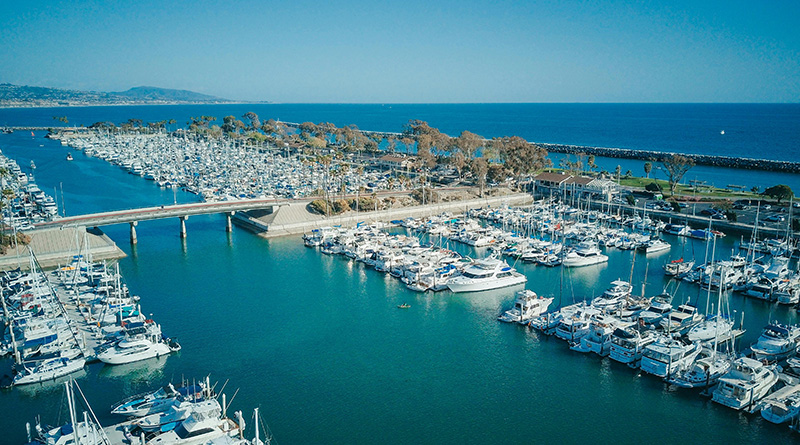
Coastal structures such as harbors, jetties and breakwaters play a central role in that distribution. Beaches that have widened significantly — including stretches of Huntington Beach and Venice Beach — often sit in “sand convergence zones,” where sediment accumulates after being interrupted by engineered structures. In some areas, beaches now exceed 600 feet in width.
However, the same structures that trap sand in one location can deprive downcoast beaches of their natural supply. For harbor communities, this dynamic is particularly significant. Ports and marinas are designed to stabilize navigation channels and protect vessels, but breakwaters and jetties inevitably alter natural sediment flow. The result can be sand buildup near harbor entrances and erosion farther along the shoreline.
For the maritime sector, that means a delicate balancing act. Sand accumulation near harbor mouths can require increased dredging to maintain safe navigation depths for recreational boaters, commercial vessels and charter operations. Meanwhile, erosion downcoast can threaten coastal infrastructure, waterfront properties and public access points that serve boaters and anglers.
Several Southern California harbors are already engaged in active sediment management to address this imbalance. Santa Barbara, Ventura and Channel Islands Harbor at Port Hueneme operate sediment bypass systems that effectively move sand past harbor structures to nourish adjacent beaches. In Orange County, sand from the Santa Ana River is routinely dredged and redistributed between the jetties in Newport Beach.
Beach nourishment projects have also shaped the region’s shoreline. Decades of replenishment work near Sunset and Surfside have contributed to wider beaches in Huntington Beach, which sits downcoast. Similar patterns are evident in Santa Monica and Venice, where gains in one area have corresponded with erosion farther along the coast.
Oceanside Harbor provides another example of how large coastal infrastructure can influence sand transport, requiring periodic nourishment projects to maintain balance.
Researchers noted that human activity is clearly influencing these outcomes. In fact, many of the most pronounced erosion “hot spots” occur near engineered coastal structures. That reality places the maritime industry squarely within the conversation about long-term coastal sustainability.
For harbor managers, yacht clubs, marina operators and waterfront developers, the study underscores the importance of coordinated sediment planning. Dredging operations are not simply maintenance tasks; they’re part of a broader coastal system that affects beaches, tourism, property values and marine access.
The research also suggests new opportunities. Because the overall sediment supply in Southern California appears more robust than previously believed, improved redistribution strategies could help address localized erosion without relying solely on importing offshore sand. Expanding bypass programs and using more precise placement methods could lead to more equitable and efficient shoreline management.
Financial, regulatory and political barriers remain significant. Sediment management involves complex permitting processes, funding challenges and jurisdictional coordination across city, county, state and federal agencies. Yet the new data may strengthen the case for proactive planning.
One of the most consequential aspects of the study is the technology behind it. Historically, coastal managers relied on costly aerial surveys and fragmented local studies to track beach changes. The use of satellite imagery now allows shoreline monitoring multiple times per month, offering near real-time insights into how beaches respond to storms, sea level rise and human intervention.
For the maritime industry, that capability is more than academic. Harbor entrances, anchorage areas and coastal infrastructure can all be affected by shifting sand patterns. Early detection of erosion or accretion trends allows port authorities and marina operators to prioritize dredging schedules, infrastructure reinforcements and shoreline protection efforts.
The timing of the study also coincides with renewed political attention on sediment management. In recent days, U.S. Senator Alex Padilla announced securing $1 million in federal funding to evaluate modifications to flood channels and dams to increase natural sand supplies to area beaches during storm events. Such efforts could further influence how sediment moves through coastal systems that include both recreational and commercial maritime facilities.
Ultimately, the findings reinforce a simple but powerful message: Southern California’s coastline is not uniformly eroding, nor is it uniformly stable. It’s dynamic, highly engineered and deeply interconnected with maritime infrastructure.
For boaters, anglers and harbor stakeholders, the takeaway is clear. Beaches and harbors do not function independently. A widening beach near one jetty may signal dredging challenges at a nearby marina. An erosion hot spot downcoast may reflect structural decisions made decades earlier.
As satellite technology provides clearer insight into these patterns, the maritime industry will likely play an increasingly central role in shaping how sediment is managed. Whether through dredging operations, harbor modifications or coordinated beach nourishment, the future of Southern California’s coastline will depend on understanding not just how much sand exists — but where it ends up.
And for a region defined by its working waterfronts and recreational boating culture, that distinction matters.