")
As boating technology continues to evolve, many recreational boaters are turning to smartphone apps to help plan trips, navigate coastal waters, and stay connected with fellow mariners. While onboard electronics such as chartplotters and radar remain essential tools on the water, mobile navigation apps are becoming increasingly popular as convenient companions for planning voyages before leaving the dock.
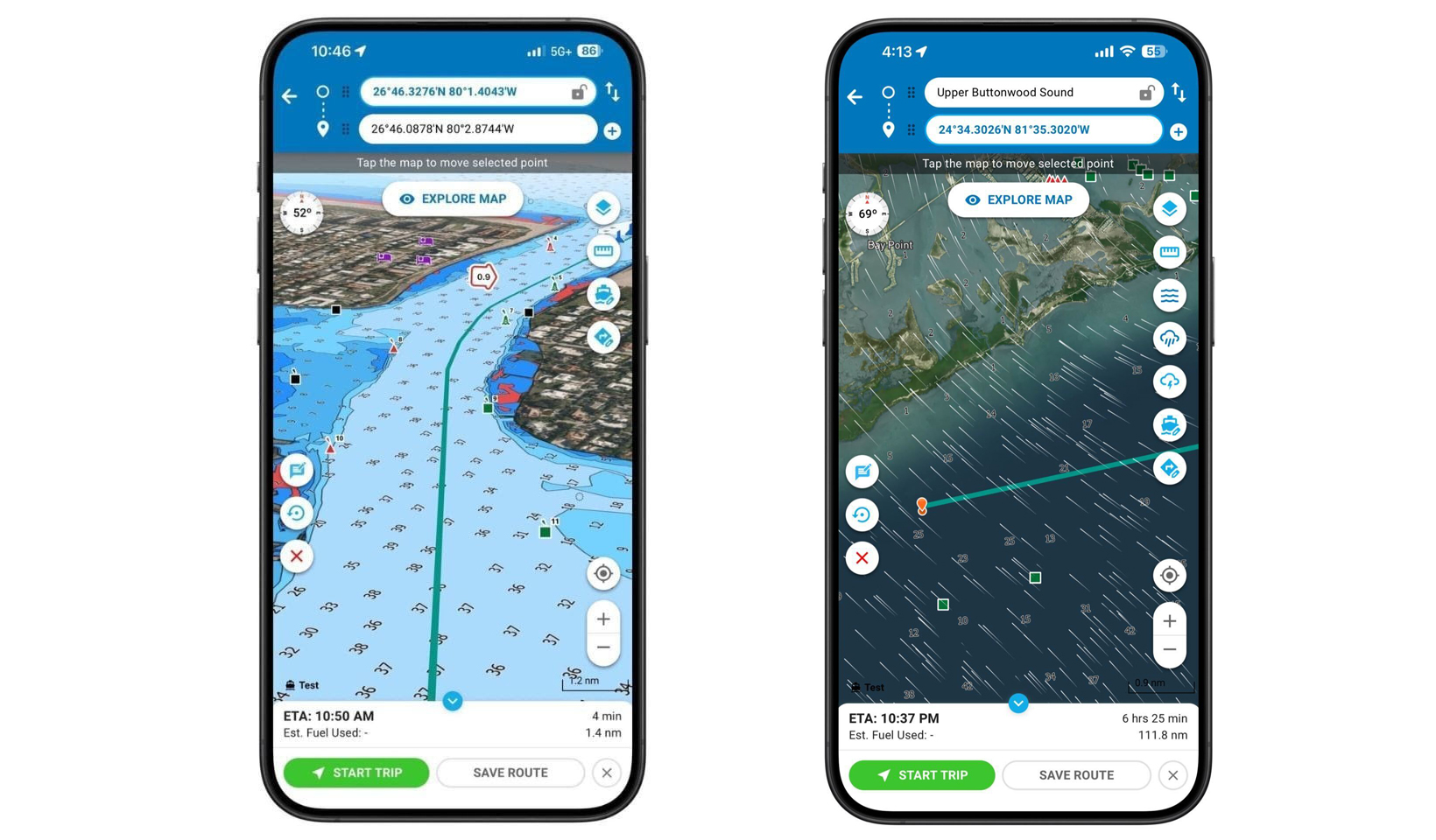
One of the latest developments in the digital navigation space comes from Argo, a marine navigation and planning app used by thousands of recreational boaters, cruisers, and boating clubs across North America. The company recently released Version 3.0 of its platform, introducing a series of improvements aimed at making route planning, map viewing, and navigation smoother and more efficient for everyday boaters.
At the same time, Argo announced the acquisition of SpotOn Fishing, a fishing-focused app known for its detailed mapping and advanced weather visualization tools. The move is expected to expand Argo’s mapping capabilities while introducing new tools designed to give boaters and anglers a clearer picture of conditions both above and below the water.
Designed to help boaters plan, navigate, and connect, Argo allows users to map routes, explore waterways, track trips, and coordinate with other boaters through a simplified interface built specifically for recreational cruising.
The most notable feature in the latest release is a significant upgrade to the app’s mapping engine. Version 3.0 now runs on a Mapbox-based system, which improves the speed and smoothness of map rendering while reducing battery consumption on mobile devices. For boaters who rely on their phones or tablets for route planning or supplemental navigation, improved battery efficiency can make a noticeable difference during long days on the water.
The upgraded mapping engine also enhances the app’s visual performance, delivering faster two-dimensional and three-dimensional chart views that allow users to better visualize surrounding coastlines, waterways, and navigation routes. The improved 3D perspective can provide additional situational awareness when planning passages through unfamiliar areas or busy harbors.
In addition to the performance improvements, Argo Version 3.0 introduces a redesigned map interface intended to simplify navigation and reduce screen clutter. The updated layout places a greater emphasis on route visibility and ease of use, helping boaters quickly interpret the information they need while underway.
The update also includes a monochrome map display option, which can be particularly useful in bright sunlight or glare conditions commonly encountered on open water. By reducing color distractions and enhancing contrast, the monochrome setting allows chart information to remain readable in challenging lighting environments.
Another new feature in the update expands Argo’s ability to integrate with onboard equipment. Version 3.0 improves route export capabilities to LOOKOUT devices, allowing boaters to move planned routes between the app and compatible hardware more easily. This added flexibility helps bridge the gap between mobile planning tools and onboard navigation systems.
The acquisition of SpotOn Fishing adds another layer of capability to the platform. SpotOn has built a reputation among anglers for its high-resolution bathymetric mapping, which reveals underwater terrain in exceptional detail. The maps highlight depth changes, contours, and bottom features that can help boaters better understand underwater structure and plan routes more effectively.
In addition to detailed bathymetry and relief shading, SpotOn provides advanced weather visualization layers that display information such as radar, lightning strikes, wind, currents, and sea surface temperatures directly on the map. By integrating these features into Argo’s platform, the combined technology aims to help users better interpret changing conditions before and during a trip.
“This acquisition is about giving boaters a clearer picture of what’s happening above and below the water,” said Jeff Foulk, founder of Argo Navigation. “By combining SpotOn’s exceptional map detail and weather visualization with Argo’s intelligent routing, we’re helping users make better decisions—before they leave the dock and while they’re underway.”
SpotOn Fishing will continue to operate as a standalone app while its mapping and weather tools are gradually integrated into the Argo platform. At the same time, Argo’s autorouting technology — designed to generate navigation routes based on factors such as vessel draft, height, and navigational constraints — will be introduced within the SpotOn app.
“SpotOn Fishing and Argo bring together industry-leading map detail and intelligent navigation to redefine the on-water experience,” said Nick Gaffney, CEO of SpotOn Fishing. “This partnership unites proven platforms and years of cross-market expertise to deliver faster innovation and more powerful tools for boaters everywhere.”
Over the coming months, users of both platforms are expected to see additional features roll out, including expanded bathymetric data, relief shading, enhanced weather layers, community route sharing, and improved communication tools.
For many recreational boaters, navigation apps like Argo serve as valuable trip-planning tools before ever leaving the dock. Users can map out routes, review distances and estimated travel times, and share planned trips with friends or other vessels in their group. These features are particularly useful for boaters planning flotilla cruises, yacht club outings, or weekend trips along the coast.
The app’s social connectivity features also allow boaters to stay aware of friends on the water, making it easier to coordinate group outings or track other vessels participating in a shared trip. For boating communities and club members, this connectivity adds an extra layer of convenience to the cruising experience.
Despite the growing capabilities of navigation apps, experts emphasize that mobile tools should complement — not replace — traditional navigation equipment and sound seamanship. Smartphone apps are often used alongside onboard chartplotters, VHF radios, and other navigation systems to provide additional planning tools and situational awareness.
Still, the continued development of boating apps reflects the ways in which technology is shaping modern recreational boating. Today’s boaters increasingly expect digital tools that mirror the convenience and functionality found in other aspects of daily life.
With the release of Version 3.0 and the addition of SpotOn Fishing’s mapping and weather technology, Argo is positioning its platform to deliver more detailed environmental insight and smarter route planning for recreational boaters and anglers alike.
For boaters planning their next coastal cruise or weekend harbor run, tools like Argo offer another way to visualize routes, organize trips, and stay connected with fellow mariners — long before the dock lines are cast off.