As cruising season wanes, boaters enjoying Mexican waters right now need to be aware that a big, bad El Niño is predicted to amp up this year’s hurricane season starting in June. Time to think ahead.
“Based on March and April 2026 forecasts from the Climate Prediction Center (CPC) – NOAA and IRI (International Research Institute for Climate and Society), … the current La Niña is expected to end, with a transition to ENSO-neutral followed by a high probability of El Niño developing June-August 2026.”
The Climate Prediction Center said, “While some earlier models in January 2026 may have suggested a longer-lasting cool phase, the latest consensus for summer 2026 is moving toward warmer, rather than cooler, equatorial Pacific temperatures. … Some models suggest a strong El Niño is possible later in the year,” according to the CPC in mid-April.
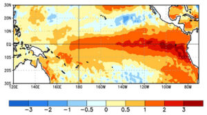
“AccuWeather reporter Anna Azallion, in a video posted to YouTube, added: ‘There’s even about a 15 percent chance it becomes a super El Niño, something we’ve only seen once since the year 2000.’ ”
AccuWeather defined an El Niño as ocean temperatures 0.5 degree Celsius or above long-term averages in that ENSO region. But a “super” El Niño occurs when it reaches 2 degrees Celsius or greater. That’s a big hike in sea temperatures.
OK, I’m convinced. So right now let’s consider how to vacate Mexico before “hurricane alley” gets dicey.
BASHING UP BAJA
Captain Jim Elfers coined the term “Baja Bash” in 1995 when he wrote a quirky little how-to book for boaters returning up the Baja California Peninsula to U.S. waters. I helped Elfers revise his original book, and my company Point Loma Publishing still publishes it.
Elfers has decades of experience delivering a variety of cruising yachts north, up the outside of Baja, which generally requires bashing dead-to-weather against both the waters of the Cold California Current and the Prevailing Northerly winds. Elfers’s book, though mixed with humorous cartoons, offers serious tips for avoiding nautical pain along a rugged coastline that provides only scant shelter for northbound vessels.
Now, add to the normal Baja Bash the new prospect of getting squeezed by Super El Niño hurricane winds and seas fast approaching from the south, and we could have a “Super Bash” this summer. Yikes! This is why all boaters in Mexico need to monitor the weather news and plot the path of all tropical storms.
In just a few weeks, each day at 0800, all the Port Captains in Mexico will begin posting and broadcasting with the latest locations of all Depressions, Tropical Storms and named Hurricanes, including their wind strengths and their direction and speed of travel. This will start June 1, 2026, utilizing VHF 16 and 22. Each port shares its local WX bulletins with a vast network, so their combined data quickly reaches national and international news networks, even NOAA. Even if we have no Starlink or Windy.com aboard, we should at least monitor the VHF at 0800 daily.
We’ll start this Baja Bash from Los Cabos, staying fueled up and ready to dash, but we must wait here for our personal WX window, based on the boat’s fastest safe speed in open ocean conditions. We’re waiting for word of a lessening of normal northwest wind strengths that is forecast to stay weak long enough for us to scoot 170 n.m. — all the way into Mag Bay. This first leg has no other anchoring shelters.
The boat needs to maintain its fastest safe speed to stay ahead of storm winds all the way up the Baja coast. Yet remember, our boat speed could get slowed down by heavy head seas from either the north or huge following seas from the south. If we’re overtaken by even the outer bands of a northbound hurricane, we could be slowed enough to not reach Mag Bay or our subsequent anchoring shelter in time.
ANCHORING SHELTERS
Magdalena Bay: Inside this huge enclosed bay (170 n.m. NW of Los Cabos), I think the best anchoring shelters in the north end are at Man o War Cove, Puerto San Carlos and the north side of Belchers Point. In the south end, shelter can be found at Navy base Puerto Cortez, in the lee of their pier. Call ahead on VHF 22. In the Soledad Channel in the far north reaches of Mag Bay, some adept shallow-draft sportfishers report finding storm shelter near the fishing town of Puerto Lopez Mateos.
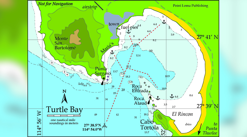
Turtle Bay, about 230 n.m. northwest of Mag Bay, is not totally enclosed. Only the south corner, El Rincon, has some land shelter from the south. But don’t be surprised to find this partially shoal bay filled with a seasonal aquaculture farm. As a hurricane moves up the coast, boats anchored near the fuel pier in the north end might need to move.
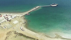
Cedros Village on the southeast side of Cedros Island (36 n.m. north of Turtle Bay) has a small breakwater-enclosed fishing harbor with a 300-foot concrete mole. When a hurricane approaches, the Port Captain allows shrimpers and commercial boats to fill the whole length of the pier and then to raft alongside three or four boats deep. With our comparatively lightly built yachts, we hope to stay on the outside of the shrimper raft up. So prepare your fenders and lines and practice your Spanish.
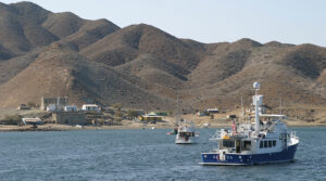
Hassler’s Cove off the SE side of Isla San Martín (155 n.m. north of Turtle Bay) is a tiny crescent-shaped bay shielded on its south side by a low, natural breakwater formed from irregular blocks of volcanic boulders. If not filled with aquaculture buoys, Hassler’s Cove provides anchoring shelter from moderate south wind. But as a hurricane eye moves north of this latitude, the island’s two 500-foot peaks may offer considerably more lee. As the storm continues north, moving the boat around to the south side of Hassler’s breakwater could be useful. But big storm seas from either direction could surmount the low irregular breakwater.
Ensenada’s two larger marinas (90 n.m. north of Hassler’s) are enclosed in beefy breakwaters: Cruiseport Village Marina lies inside its own breakwater inside Ensenada Harbor’s enclosing breakwaters, and Marina Coral just north of town has its own enclosing breakwater.
Thanks to cooler ocean water temperatures, full blown hurricanes seldom have survived to reach this far north. In my August column, we’ll look at the so-called “hurricane holes” for boaters along Pacific Mexico.
But meanwhile, hold on to your Stidd, skipper! Nobody knows exactly where this new hotter Pacific will generate its first hurricanes and how fast they’ll be able to travel during this Super El Niño summer of 2026.