")

Ken Englert is the president of Maritime Communications, a Marina del Rey-based marine electronics dealership that’s been in business for more than 50 years. He’s seen all the advances that have been made in marine electronics and is an ardent proponent of having a chartplotter aboard any boat that heads out into the Pacific Ocean.
Today’s chartplotters are so easy to use that even if you’re a novice, you can plot a course with two taps on a screen.
“It’s to find out where I am and how to get to where I want to go,” he said. “With the touchscreens we’re using today, you can do it by tapping on the screen.” First tap your current location — it’s displayed on the screen — then tap your destination. Voila, your course is displayed.
Provided there aren’t any structures or large vessels in your path, just follow the line on a screen.
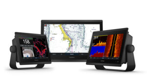
(credit: Garmin International)
In an email exchange, Carly Hysell, associate director, public relations for Garmin International explained that the basic function of a chartplotter is, “to show electronic marine maps and navigation on a bright, easy-to-read display at the helm.”
When networked with other devices, chartplotters act as integrated multifunction displays that show charts and act as the central control hub for a host vessel. They can display sonar, radar, cameras, autopilots, VHF radios, audio entertainment sources and more. When asked what the biggest advantage of having a chartplotter, Hysell’s response was instant: “Enhanced situational awareness — knowing more about what’s around (navigation, safety, vessel integration and more) can help be the difference between a good or great day on the water.”
For a person who is on the fence about purchasing one, Hysell adds, “A chartplotter can add a layer of navigation, safety and convenience — plus having up-to-date and accurate information is priceless and can make your time on the water more enjoyable.”
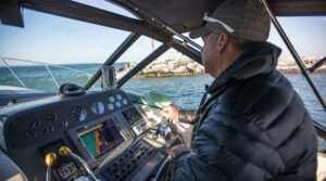
(credit: Discover Boating)
Want to keep an eye on the engines while you’re under way? Integrate a camera from the engine compartment into your chartplotter. You can do the same with cameras in cabins to ensure that the kids are behaving. If you want to see farther ahead than a human eye is capable? Add radar to your plotter.
“It makes up for a lot of poor seamanship,” says Englert. “I would rank that quite high-safety wise.”
Historically a chartplotter was only used for navigation and have become synonymous with multifunction displays. The two terms are used interchangeably.
When a customer goes to Maritime Communications asking about a chartplotter, he starts with the basics. “I ask them what kind of boat they have,” Englert said. “Are you a cruiser, a daysailer or a fisherman, or are you going to go around the world?”
If you’re a fisherman in California, one thing that a chartplotter helps with is keeping you up to date on no-fishing zones. “They change in a moment’s notice,” said Englert. “It will pop up on the screen and you’ll see the zones.”
As with any substantial purchase, it’s rare that a person will walk into an electronics dealer or store like West Marine without having done some research. Garmin, Raymarine, Navico, Simrad, B&G and Lowrance are some of the better-known brands.
With this in mind, Englert asks customers if they have a preference, then works with them based on that. To be able to provide an image of a coastal area, a plotter needs to have a chart card. Most come from C-Map or Navionics and coastal charting of the United States is the default chart in most units.
“That would give you enough to navigate somewhere,” said Englert. A boater who wants more detailed cartography for a given area or who plans to head to the Caribbean or other area can purchase dedicated cards. They range between $200 and $300, according to Englert.
In 2006, the Automatic Identification System was introduced for pleasure vessels. Each vessel has an AIS identifier and plotter equipped with the technology that lets the user see other AIS-using vessels in the area, which plays a significant role in collision avoidance.
When it comes to screen sizes, Englert says that 7- and 9-inch units are popular on boats with confined helm space. Many captains will add a smaller screen at an upper station and many anglers want one in the cockpit.
Garmin’s most popular chartplotter is the GPSMAP series that ranges from 7 to 27 inches for screen sizes. Retail prices for the GPSMAPs ranges from around $1,100 to $16,999 depending on size and functionality.
As with any product intended to assist with navigation, a chartplotter doesn’t relieve a captain of the responsibility to pay attention and maintain watch at the helm. A plotter can be tied into an autopilot, but Englert warns, “You still need to pay attention. It’s like a superhighway out there. You have distractions in all directions.”