")
In modern sportfishing, decisions are often made far from the water’s edge. While experience and instinct still matter, access to accurate, real-time data has become a core strategy for boaters targeting offshore pelagic species. Among the most utilized resources are fish mapping tools that incorporate sea surface temperature (SST), chlorophyll data, and user-reported fish activity. Two of the most prominent services for Southern California anglers are Terrafin and FishDope, each providing a different but complementary approach to locating productive water and maximizing fishing success.
Satellite-Driven Strategy
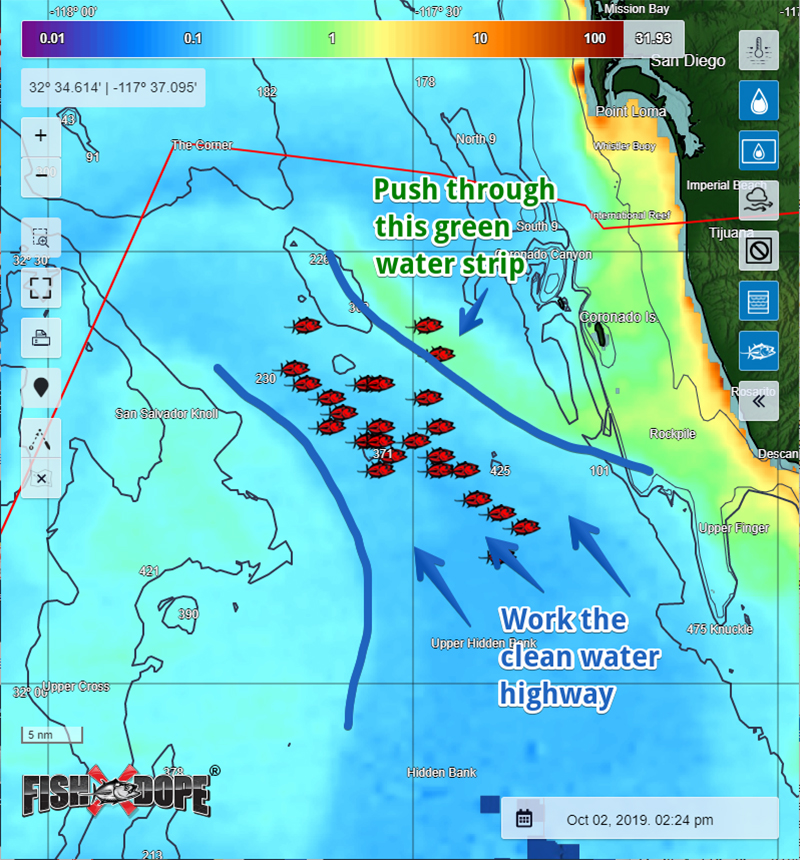
Sea Surface Temperature (SST) and chlorophyll charts have become essential tools for locating gamefish. Certain species, like yellowfin tuna and dorado, tend to follow thermal breaks — boundaries between warm and cool water — where bait tends to aggregate. Chlorophyll data, which measures plankton density, offers insights into water clarity and productivity. These satellite-based overlays allow anglers to narrow their search area before leaving the dock.
Jeff Gammon, founder of Terrafin, developed one of the first accessible SST mapping tools for West Coast anglers. “We started creating the Terrafin Sea Surface Temperature charts at the end of 1997. The problem we were trying to solve was simple — we weren’t very successful on our own offshore fishing trips,” Gammon explained.
Frustrated by inconsistent catches and limited range, Gammon and his friends began manually creating charts from NOAA data. “The first charts we made involved zooming in, printing them out, and manually drawing lat/lon lines with a ruler and pen. It took about four hours to do the first ones,” he recalled. The effort paid off. A winter trip guided by one of their hand-drawn SST charts yielded four albacore tuna. “We were sold on it,” Gammon added.
Today, Terrafin’s digital product, SST-View, delivers enhanced SST and chlorophyll charts for the entire U.S. coastline, Hawaii, Mexico, and beyond. Users can download and view the latest imagery using a web-based portal or mobile app, even when offshore. “Before going out, users can view and download the latest charts from our website. SST, chlorophyll, whatever they like. So now these charts are stored on the phone or tablet. Offshore, even without a signal, the charts can be pulled up since they’re stored on the device,” Gammon said.
For divers, Terrafin added chlorophyll data in 2006. “Divers are a smaller group for us, but they do love the chlorophyll charts to predict the visibility for a dive trip,” he shared.
The service offers additional features such as distance and bearing tools, a chart loop animator to visualize trends, and a mouse-over function for pinpointing lat/lon coordinates and temperatures. A subscription, priced at $119 per year, provides unlimited access to all regions and archived data.
Human Intel Meets Satellite Imaging
FishDope, founded in 2009, combines digital mapping with firsthand reports from professional captains, private boaters, commercial vessels, and a dedicated spotter plane. The service includes SST and chlorophyll overlays, but its distinguishing feature is its human-verified reporting system.
“Our team of reporters has over 100 years of combined experience with our local SoCal saltwater fishery, and every day of the year we talk with our extensive network of contacts spanning private boaters, charter boat captains, and commercial fishermen to keep track of what’s biting where. This helps us cross-check and verify all the info that comes across our desk, cutting through the rumors, hype, bogus ‘radio fish,’ and old reports to make sure we’re only posting legit, solid info that we ourselves would be willing to chase down the next day,” said Jeff Barr, PhD, Product Manager for FishDope.
Reports are posted daily, typically between 4:00 and 5:00 p.m., then updated into the evening. These include GPS coordinates of recent bites, bait presence, bird activity, and kelp paddies. To supplement on-the-water reports, FishDope uses a spotter plane to survey offshore waters from July through October.
“The plane gives us a great big-picture view of how big an area the main bite zones cover, helps us get back on fish when the fleet loses track of them, and lets us scout new areas that look fishy on the charts to put our members on fish out away from the crowds,” Barr said.
FishDope’s mobile app is designed with offshore conditions in mind. “We specifically designed the mobile app to be offshore-ready to give our members full access to all our reports and charts while they’re out on the water, even without cell service. When a FishDope member looks at our daily reports in the app while they’re at the dock getting their boat ready, or if they pull up a map to see SST, chlorophyll, or any of our other map layers, everything they look at automatically gets cached (saved) to their phone so that it’s available later when they’re offshore and offline,” Barr explained.
This offline functionality is a critical feature, especially when paired with GPS chips embedded in most smartphones. FishDope users can view their location relative to fishing reports, temperature breaks, and chlorophyll gradients, even out of range.
Understanding Chlorophyll
Both Terrafin and FishDope integrate chlorophyll data to aid anglers in identifying water quality. “The chlorophyll layer shows how much plankton is in the water, which is the base of the food chain (good) but also makes the water murky and hard for gamefish to find bait hiding in the murk (bad). We typically like to focus our fishing effort along the edges of plankton blooms where gamefish are patrolling for baitfish that are drawn to the plankton food source but then stray out into the clean water,” Barr said.
This type of edge-fishing is particularly effective for tuna, which patrol boundaries between nutrient-rich green water and clean blue zones. Using chlorophyll layers in tandem with SST charts helps anglers refine their targets by identifying productive conditions, not just structure or historical reports.
Product Design and Features
While Terrafin emphasizes clarity and simplicity in its design, it includes robust tools for route planning, float plan generation, and trend analysis. Its altimetry and currents charts are included at no extra charge. Gammon noted, “Our focus is to make sure that we use the highest resolution data to begin with and create our charts from that data. We also work a lot on processing data from alternate sources. The goal is to keep the data flowing, even when there are problems with our preferred data sources — and there always are, usually at the worst times!”
One of Terrafin’s recent updates includes a new daily SST composite. “We’ve always shied away from multi-day composites because they tend to not be particularly accurate,” Gammon said. “But the single-day composites seem to be much more accurate, and they’re very helpful in areas where there’s a lot of cloud cover that moves around.”
FishDope has invested heavily in interface upgrades, with more enhancements in development. “Over the last two years we have added several high-definition bathymetry maps to help show detailed habitat and rocky reef structure for bottom fishing, and we are continuing to add new high-definition regions throughout the SoCal Bight. We also have a major behind-the-scenes overhaul of our mobile app and map technology that we anticipate launching soon this summer. This update will support some new features coming later this year and next that we can’t share publicly quite yet, but we’re really excited about them and know they’ll be a great benefit to our members,” Barr said.
The platform also includes streaming VHF radio, allowing users to monitor live offshore chatter while still at home or in the marina. “We built the live streaming VHF feature based on our own experiences of getting the boat ready to fish the next day. We would turn on the boat’s VHF radio to listen in from the driveway or boat slip to gather intel as boaters shared info on the water with each other,” Barr shared.
Origin Stories and Mission
Terrafin began as a solution for private boaters who lacked the range and resources of large charter operations. “Terrafin was the name of our boat,” Gammon shared. “We started with ‘Terrapin’ from the Grateful Dead album Terrapin Station, but decided that wasn’t fishy enough. So we went with Terrafin.”
FishDope started with a similar mission. “FishDope originated… from the minds of two SoCal private boaters who figured out how to make a technological tool to do what they had been doing by hand for years — gathering fishing reports and GPS coordinates from their buddies and then marking the locations on printed-out SST charts to match up the bite with water conditions,” Barr said.
Their shared philosophy is rooted in reducing wasted time and fuel. FishDope’s slogan — “Catch more fish, burn less fuel” — has resonated with boaters from Santa Barbara to Ensenada.
Application in Practice
The practical use of fish mapping tools is often illustrated through scenarios that emphasize efficiency. An angler planning a trip to target yellowfin tuna might use FishDope’s reports to identify a bite that has shifted 15 miles east. Instead of running blind, the angler downloads the updated charts and coordinates at the dock, adjusts their route, and arrives on fish within hours.
Terrafin users may take a similar approach, using SST breaks and chlorophyll edges to identify water transitions before plotting a route with the distance and bearing tool. Offshore, the vessel’s GPS location can be displayed on the stored chart to confirm alignment with the desired temperature band.
Regional Relevance
Both tools cater to the Southern California fishing community but offer flexibility for travel. Terrafin includes access to all chart regions under a single subscription, allowing users to switch between locations like Baja, the Gulf of Mexico, or Florida as needed. FishDope focuses specifically on the Southern California Bight and adjacent Mexican waters, including Catalina, San Clemente Island, the Coronado Islands, and local inshore fisheries.
FishDope’s annual membership is $199, while Terrafin’s is $119. Each offers features tailored to different angling styles — one with heavy integration of aerial and ground reports, the other with a refined approach to satellite interpretation.
Fish mapping has become a core part of sportfishing strategy, offering insight into ocean conditions that affect fish behavior, location, and activity. Services like FishDope and Terrafin provide anglers with complementary tools: one emphasizing observational reporting and integrated intelligence, the other focusing on high-resolution satellite visualization and planning features.
For those fishing Southern California and beyond, adopting a data-informed approach may no longer be optional. As fish patterns shift with climate, currents, and pressure, real-time tools that integrate satellite data, human observation, and mobile access can give anglers the edge they need.
Both platforms are available by subscription and provide ongoing support, updates, and offshore functionality for modern recreational anglers. Subscriptions can be accessed via fishdope.com and terrafin.com.