")
Here’s one of the most rewarding itineraries for winter cruising season, long favored by veteran cruisers — both power and sail. But because at first this itinerary may seem strenuous or counter intuitive, it requires a bit of explanation.
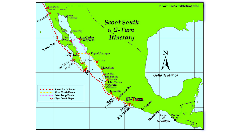
This plan is to scoot south down the outside of Baja and mainland Mexico as fast as is safely possible for your boat and crew, about 1,350 n.m., (Yikes!) skipping lots of inviting places along the way (Oh, no!). But then stop at Ixtapa — Zihuatanejo and rest for a week or two, then make the big U-turn and aim northwest. Begin there to slowly gunkhole your way back up the mainland coast — stopping to enjoy at all those legendary destinations you regretted bypassing during your fast-and-furious scoot south. With the coast almost always on your starboard side, continue coasting leisurely way up into the southern Sea of Cortez (Gulf of California). Worth it? You bet.
- The outside of the Baja Peninsula is infamous for its blustery northwest winter winds and lack of reliable stops for fuel, rest and refuge. Overnight stops are found at Ensenada, Turtle Bay and Mag Bay. Boats with sufficient fuel range and crew abilities can surf south without stopping. But some folks might opt to carry an extra crew member just for these first five or six non-stop overnight legs, and they can fly home from Los Cabos. (See the red line on the chart indicating the “Scoot South Route.”) Don’t regret zooming past outer Baja now; you’ll see every desolate inch of it later while Baja Bashing your way back north.
- You can flee winter weather by getting south into the tropics as fast as your boat can take you. Winter weather conditions across the southwest U.S. will still feel like winter when you’re in northwest Mexico. You can’t pack away the thermal undies and foul weather gear until you turn the famous corner at Cabo San Lucas. Then it’s time to break out the swimsuits and sun block. If you’re not into cold weather cruising, it’s wise to keep pointing your bow south for now, to avoid the mid to upper reaches of the Sea of Cortez until spring or early summer.
- Crossing the southern Sea of Cortez is a genuine offshore passage. In winter, this passage is usually safer and a much more comfortable ride when you’re angling southeast, not bashing northwest. But before jumping off southern Baja, savvy skippers will wait for a sufficient weather window. Then lay your safe and straight course to make landfall on the mainland anywhere from Banderas Bay to Barra de Navidad.
- Need another reason? Scooting across the lower Sea of Cortez now (with wind and waves comfortably on your port quarter) allows you to stay within milder coastal conditions along the mainland later — whenever you return north. See the chart, following the red line or Scoot South Route verses the yellow line for Slow North Route

On the mainland, it’s about 300 n.m. from Cabo Corrientes down to our U-Turn destination. (See chart.) Because the marinas in Acapulco harbor are reportedly not yet completely recovered from massive hurricane damage, for now the U-turn destination of Ixtapa Zihuatanejo provides a better alternative. This cruising and fishing resort area in the state of Guerrero is a perfect place to rest up after your fast scoot, to refuel and reprovision. Here you’ll find two uniquely different resort towns (Ixtapa vs. Zihuatanejo), a full-service marina with fuel dock and haul-out yard plus dozens of pleasant places to anchor, dive, fish and explore ashore. Because this will be your first place to completely unwind, don’t get too comfortable. Much more of the good stuff awaits.
After making this U-Turn, the northbound route (See chart, yellow line for Slow Route.) is almost completely coastal. Yay, no more big jumps offshore. From now on your route mostly stays close to shore, so you can make short comfortable hops between dozens of Mexico’s most desirable destinations. The coastal terrain will change enormously from the Sierra Madre foothills of Guerrero, volcanoes in Colima, tropical jungle of Jalisco, Nayarit and Sinaloa, and finally to the stark Sonora desert. Your life has entered “cruise mode,” so from now on you can travel more slowly, linger longer and develop a healthy case of “cruiseheimers.”

The pink loop starts at Topolobampo (Don’t miss!) and point-hops 175 n.m. north past lush lagoons up to the Sonora twin ports of Guaymas-San Carlos. Marinas and anchorages in these two small ports house the second largest year-round liveaboard community in Mexico. Thanks to many marinas with swimming pools and ample shore power for air conditioning, Guaymas-San Carlos has become one of the most popular places to summer over. That’s also thanks to several summer storage boat yards known as “marinas secas.”
Departing from San Carlos, this pink line route now angles east and crosses the Sea of Cortez to arrive at Baja’s tiny Santa Rosalia in only 65 n.m. Heck, on a clear day, you can see across. From Santa Rosalia the 120-n.m. coastal route south to Loreto and Puerto Escondido encompasses the second-best cruising grounds in Mexico. That includes Punta Chivato, Mulege, Bahia Concepcion, San Juanico with the Cruisers Memory Tree, and the many anchorages around Isla Carmen that lies close off Loreto and Puerto Escondido. For cruiser news from Marina Puerto Escondido, see my “Mexico Report” in The Log’s previous issue.
From Loreto, the 115-n.m. route south to the minor port city of La Paz has so many unique and pristine anchorages (See * below.) that it’s known as THE very best cruising grounds in Mexico, rated by several magazine surveys, and La Paz is home to THE largest liveaboard community of boaters in Mexico. Each year, more big regattas are ending here rather than at Los Cabos, and more boats and crews are getting prepared here for long hauls to elsewhere.
* Not to be missed, this magical 115 n.m. stretch contains many tiny but legendary destinations such as: Isla Carmen, Isla Danzante, Agua Verde, Gato and Toro, San Evaristo, Isla San Jose with its remarkable Bahia Amortajada lagoon, tiny Isla Coyote as the only inhabited island in the Sea of Cortez, and within sight of La Paz are the vast Islas Espiritu Santos with 35 pristinely protected anchorages. Intelligent boaters spend years soaking up the beauty and culture.
After such grandeur, finishing the Yellow Slow Route from La Paz down and around to Los Cabos might almost be anti-climactic. Well, except for the historic silver-mine anchorage in Bahia de Muertos, the living coral reef system within Cabo Pulmo National Marine Park, and the world-class sportfishing along East Cape and atop the Gordo Banks off Los Cabos.
READY TO RETURN?
Before beginning the infamous “Baja Bash” to return stateside, a two- or three-day stop to prepare and provision at either San Jose del Cabo or Cabo San Lucas can be difficult to arrange or impossible. That’s due to the fact that all the local marinas are experiencing a slip shortage, and that’s due to their policy of allowing all slips to be reserved for years in advance. Maybe get it done in La Paz.
Tune in next time for a deep dive into the Baja Bash. Capt. Jim Elfers’ classic book “The Baja Bash” is required reading for anyone contemplating making this oft required northbound voyage up the outside of Baja. Combining humorous anecdotes with savvy technical advice, Elfers’ book “The Baja Bash” is available at MexicoBoating.com.