")
As we cross oceans on our vessels, we spend a great deal of time studying our chartplotter, autopilot, depth sounder, radar, AIS transponder, knot meter, wind speed indicator and so on, while also tending to the deck winches just to squeeze that extra half knot of speed out of our sails. That’s a lot of information to be churning in our heads as we constantly make decisions and course corrections on the path to our next landfall.
Until recently, Ethernet technology was the only option we had for bringing all of these devices together on one chartplotter. But Ethernet requires laying cables and junction boxes, a challenging, time-consuming job on most vessels. The type of system we now see more frequently on ocean-going yachts is a wireless interface connecting the various navigation devices via W-Fi or Bluetooth. Now we can wander from the head to the masthead with cell phone in hand, constantly informed of changes in heading, engine temperature, wind direction and speed, etc.
Before installing a new electronic system on your vessel, ensure you have enough space on your DC switch/fuse panel to accommodate all the devices you plan to install, plus a few extra switches for future equipment installations. If you need a custom panel, AC/DC Marine in Torrance, CA, is ready to produce any type of electrical panel you can dream of at a very reasonable price.
Every time I take off sailing to the California Channel Islands on my Cal 30 sloop Saltaire, I deploy the windvane self-steering system, switch on my Garmin 64cv chartplotter, tap the ActiveCaptain app on my iPhone and walk about my vessel, enjoying the sail while taking glances at my progress on the iPhone screen. I spend hours away from the tiller, still out on deck as long as I’m within 100 miles of shore, but free to nod off for short catnaps, secure knowing that I my precise location without the need of the chartplotter under the spray dodger.
For skippers looking for a multi-input, reasonably priced navigation instrument array, the Garmin Wireless GNX Sail Pack is a popular option. The GNX Wind Instrument, available as part of the larger package, consists of a glass monochrome LCD display with several backlit colors from which to choose. The Wind Instrument indicates true and apparent wind direction and speed, steering feedback, vessel speed and other data.
Garmin’s gWind Wireless 2 Transducer features a three-blade propeller with Nexus twin-fin technology capable of transmitting wind data from the masthead (up to 50 feet) to the display at the helm. The entire kit, which communicates via NMEA 2000 network, includes a ST810 thru-hull Smart Transducer and GNX 20 color display. The whole Garmin GNX Wireless Sail Pack installation kit is available through the GPS Store online for a very reasonable $1,000.
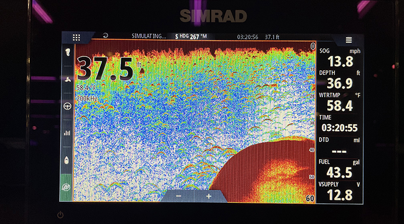
The Simrad GO9 XSE Fishfinder/Chartplotter Combo comes in a kit with a “three-in-one transducer and C-MAP Pro Discover Charts,” opening a whole new way of navigating the aquasphere. The widescreen, multi-touch display with LED backlight makes navigating in coastal and open-ocean waters far easier than having to look back and forth between depth sounder and chart to stay safe in coastal areas.
With the Simrad GO9’s NMEA 2000 connectivity, you can integrate the chartplotter with a Simrad autopilot, a CHIRP sonar with SideScan and DownScan Imaging to keep you apprised of potential dangers, a particularly important feature if you plan to cruise through South Pacific atolls, where towers of coral just below the water’s surface could otherwise slice a hole in your hull and have you scrambling for the life raft.
The B&G WS320 wireless wind sensor, like several other navigation sets on the market, is available as part of a package, which includes a DST810 Multisensor thru-hull transducer, a ZG100 GPS antenna and a micro-C backbone kit running on a NMEA 2000 Micro-C network.
The WS320 wind sensor is designed to support crew with uninterrupted data, which includes apparent wind speed and angle data reported at a speed of five times per second. The B&G DST210 thru-hull combination sensor measures speed with a paddle wheel, depth with a transducer and temperature with a reliable, submerged thermometer. Completing the B&G package is a ZG100 GPS antenna, which provides B&G chartplotters with fast, reliable data transmission.
If you are looking for a stand-alone battery monitor, consider the Victron Cerbo GX, “a hub for all energy on board.” To be sure, other monitoring systems also have jumped straight ahead to cellular apps, using Wi-Fi and Bluetooth technology to keep us informed of battery charge and the overall performance of our onboard electrical systems. Xantrex, Siren Marine, Oceanic Systems, Naut Alert and other manufacturers offer dependable battery monitoring systems, complete with shunt and wireless connection, providing detailed data on battery charging and performance.
The center of the Cerbo GX is a small, blue box, or hub, with eight analog inputs for temperature readings, depth sounder, water and fuel tank levels, etc., plus four digital inputs for battery charge monitoring. With four battery sensors, you can keep tabs on the starter battery, house bank and two reserve banks from a single screen on your chartplotter while on passage.
If you still need the added convenience of connectivity to the cloud, you can use the Cerbo GX as a Wi-Fi server in the same manner as its competitors. In order to connect to the Internet, you will need access to a Wi-Fi or LAN network, or a GX GSM network.
While you are away from the vessel, you can use the Cerbo GX Internet connection to keep yourself apprised of battery charge, which offers clues to other electrical activity occurring on your floating palace during your absence. If you are 200 miles inland on a road trip and you notice a sudden charge drop in one of your house batteries, this could indicate a spontaneous, unexplained firing-up your electrical system, or just as bad if not worse, a short that could cause a fire.
The Cerbo GX from Victron Energy is compatible with virtually all chartplotters, including Raymarine, Garmin, Lowrance/B&G/Simrad, Navico and Furuno. At roughly $340, it is hard to imagine a more sensible investment for your vessel’s battery management system.
Whether your vessel is more easily managed through an Ethernet router with Wi-Fi access or a fully wireless network, you have many options available. Choose the system best suiting your needs for ease of installation and use, and as always, your requirements for vessel security.